


A Nabatean city in the Negev – Avdat
by Richard Benishai | Articles
Geographical location
Avdat was set at its present location (see Figure 1) as a converging point for the various caravan routes crossing the Negev desert. It was founded in the first century BCE (before the Common Era). A temple complex and public buildings were visible from far and served as a landmark for caravans.
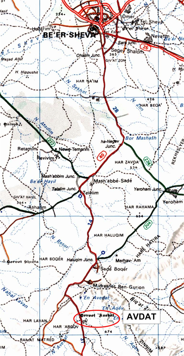
Figure 1 : Avdat on the map

Survey of Israel
Avdat was established as a rest and recuperation point for the tired caravans, by the Nabateans (1), in the first century BCE. This city had a complex canalization system to gather and store the meager yearly rain fall.
Avdat as a hi-energy site
Spurred on by a friend, I undertook to research this supposed-to-be hi-energy location. From my home, I checked the location on an aerial picture (see Figure 2).
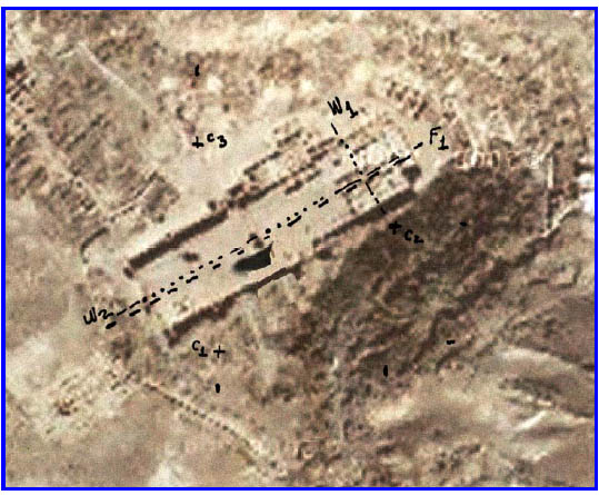
Figure 2 : Preliminary site search
Using my pendulum, I found that there was a fault (F1) and an underground water stream (W2) running right down the middle of the site. I discovered also another water stream (W1) crossing the front part of the site, at the Northern Church. While searching for chimneys, I located 3 such phenomena (C1-C3).
For more information about chimneys, please read our article : Chimneys and vortexes.
There were two energy lines connecting chimney C3 to C1 and to C2. Each line was about 1.30 to 1.60 m wide, with an energy level of about 1.2 million Bovis.
This was enough evidence to warrant a long trip to Avdat, from my home, 2 hours away.
The first trip
On the 17th of May, I went to Avdat, hoping to enlist my son’s help. My son, Tal, was a student in a nearby school, directly north of Avdat and a few minutes away (Midreshet Ben Gurion – a college). Unfortunately he was away on a day trip. So I headed out alone. It was a hot day and I got burned by the heavy sun. There was no humidity, so it was comfortable being in the heat.
Note : throughout this paper several terms are used that may be strange or new to the reader. For details on the meaning and definition of the parameters used in characterizing the singularities, refer to the article on Energy Parameters.
I started looking for the first chimney (C3 in Figure 2). This chimney was located exactly in front of the winery (see Figure 3). In Figure 3, the center of the chimney is indicated in red. The outside marks of this chimney are also indicated in this figure.
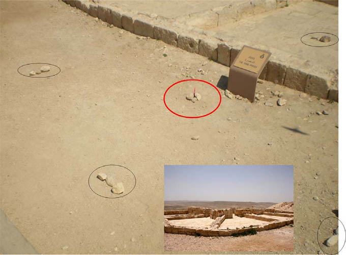
Figure 3 : Chimney C3 location in the winery
Location C3
Type of entity : chimney
Energy level : 2 million Bovis
Vibration color : white
Type of world: divine (43)
Active time (rise/fall) : 2 min. 10 s
Rest time : 50 s
Size : 4 m dia.
From this location I started to look for links to the other two chimneys (C1 and C2). The links were located for the two other chimneys. The link from C3 to C2 was about 1.60 m wide and its energy level was at 1.2 million Bovis. The second link, from C3 to C1 was 1.35 m wide and had a similar level at 1.2 million Bovis. The other two chimneys were checked, with the results following. The chimney at location C2 was on the very edge of the cliff. The center of C2 is indicated in red, with the perimeter shown in yellow. It is not surprising that the perimeter has an elliptical form, as it was discovered for the chimneys of Mount Tabor as well as other places. What is interesting about the location of the chimney is its closeness to the edge of the cliff.
Location C2
Type of entity: chimney
Energy level: 2.2 million Bovis
Vibration color: white
Type of world: divine (46)
Active time (rise/fall): 1 min.
Rest time: 35 s
Size: 2.60 m dia.
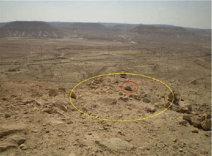
Figure 4 : Location of chimney C2
The third chimney detected, C1, was directly opposite to C2. See Figure 5.
Location C1
Type of entity: chimney
Energy level: 1.7 million Bovis
Vibration color: ultra violet
Type of world: spiritual (42)
Active time (rise/fall): 50 s
Rest time: 45 s
Size: 2.30 m dia.
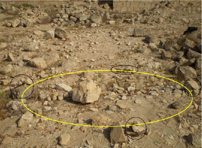
Figure 5 : Chimney C1 location
The channeling
After my first trip to Avdat, I asked my good friend and co-worker, Géèma (his channeling name) to do some channeling about the place and the work I had done so far. Géèma, also a geobiologist, has the special ability to see the invisible to the naked eye. Here is a partial transcript related to Avdat :
“In ancient times, communications among men was accomplished by making very long voyages by foot or by riding animals. Often, it would take over 10 days to arrive at a place where men, women and children could find rest and recuperation, regenerate their dehydrated cells, eat and sleep. To this end, they created this station [Avdat], where they could regenerate themselves, before being on their way, once again. They would sometimes travel with their family and would return only after a few years. Using their mental powers and spirit, they created a site with high vibrations, not only to recuperate, but also to connect with their higher self. During their long night of sleep, they resolved problems on other planes (other worlds).
At very regular periods, ecumenical thought forms would be created, due to the various types of beliefs and religions, gathering at this site. The main idea was to connect to the Supreme Being part of themselves.
What you are measuring today, is the memory of the rocks and of the earth of past events. This triangle [C1, C2 and C3] is a healing zone, for those suffering of general weakness and loss of health. Those people have to visit here and you will be surprised at their recuperation speed.
It would be quite wise to create at this location an infrastructure to allow certain people to sleep there, the regeneration work being done at night. Avdat is part of the 18 high-energy sites. Each site has a function in correcting health. Via your writings and requests, this location will open. Define and mark the exact locations in your article. Your idea will be captured by someone who will set up the infrastructure.”
Second trip
Based on the information obtained via channeling, I returned to Avdat on the 14 of June and this time with my son Tal. We were looking for the exact locations of the first 3 chimneys, so as to identify them on a map, this in accordance with the instructions I had received via channeling. So I found the 3 chimneys and together we took distance measurements.
Then, my son said: “Why don’t you look for other chimneys?”.
I did and found 3 more. The entire network of chimneys is detailed in Figure 6. The previous 3 chimneys have been renamed. The exact locations are defined by detailed drawings with measurements in the next figures (Figures 7 thru 11).
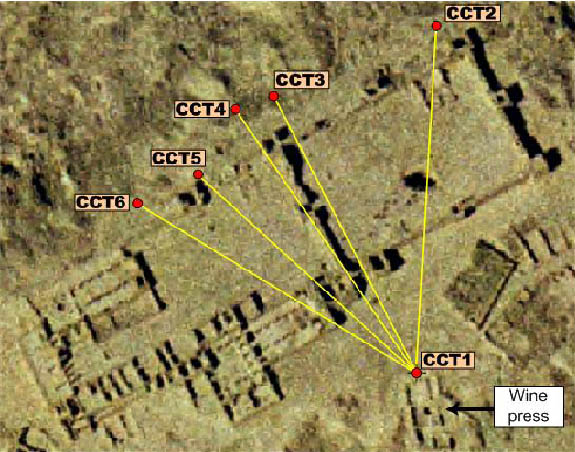
Figure 6 : Layout of the chimney network
Details on these chimneys are :
| Chimney | Energy level(Bovis) | Size (m) | Before |
| CCT1 | 2 000 000 | 4,0 dia. | C3 |
| CCT2 | 540 000 | 2 x 1,25 | |
| CCT3 | 580 000 | 2,60 dia. | |
| CCT4 | 1 700 000 | 2,30 dia. | C1 |
| CCT5 | 2 200 000 | 2,60 dia. | C2 |
| CCT6 | 600 000 | 2,30 dia. |
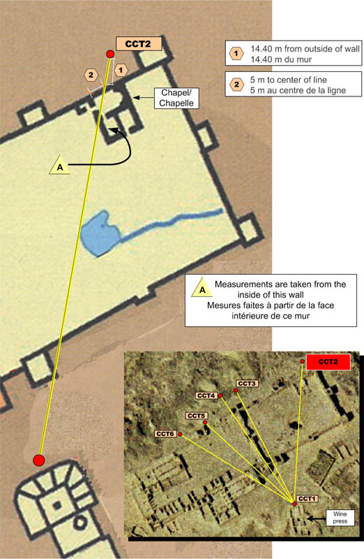
Figure 7 : Location of chimney CCT2
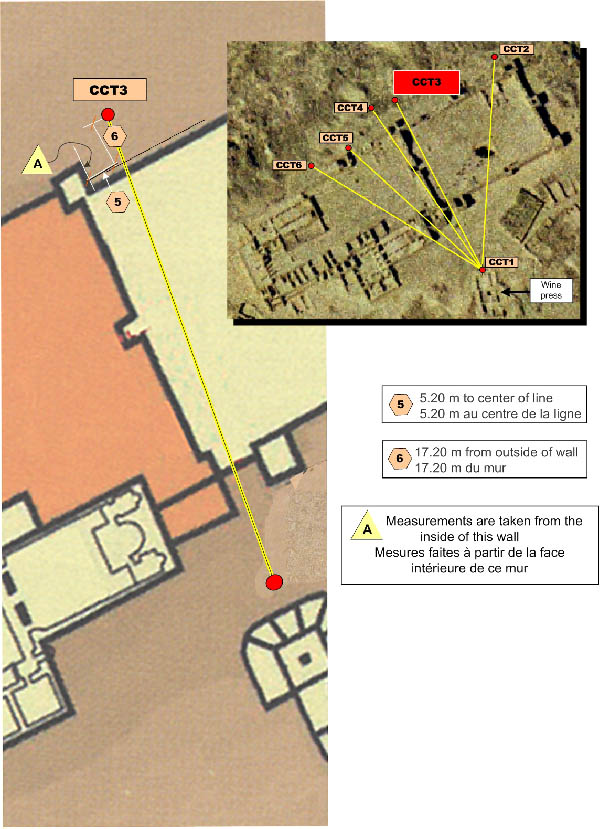
Figure 8 : Location of chimney CCT3
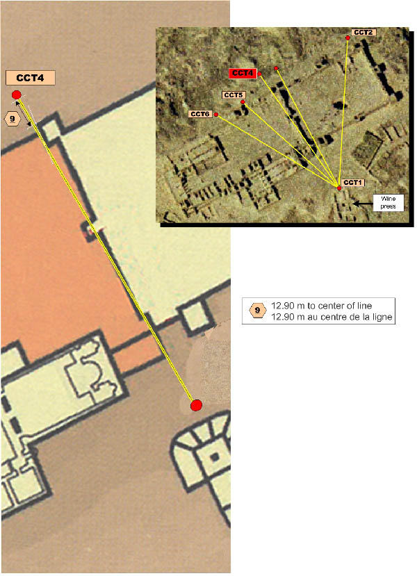
Figure 9 : Location of chimney CCT4
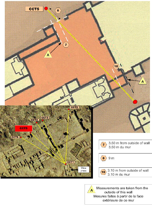
Figure 10 : Location of chimney CCT5
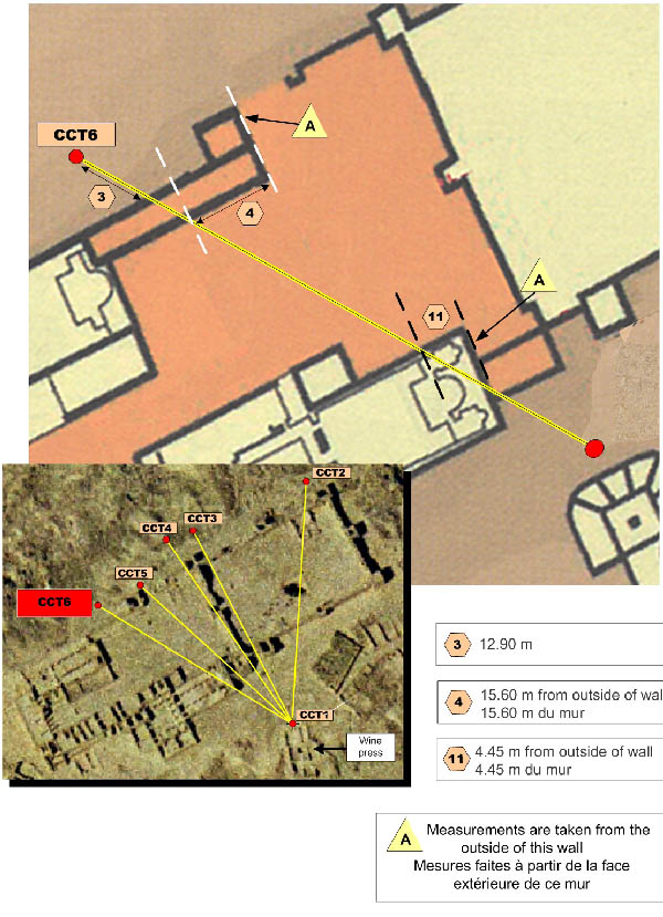
Figure 11 : Location of chimney CCT6
Related geobiology finds
I checked a few other things, related to geobiology, such as faults, underground water streams and electromagnetic networks. Hartmann and Curry lines form part of electromagnetic global networks, running North-South/East-West for Hartmann. The Curry network is 45 degrees shifted (NW/SE and NE/SW) in relation to the Hartmann network. An overall drawing of the entire area is given in Figure 12.
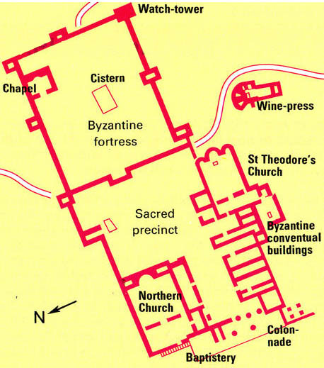
Figure 12 : Overall layout of Avdat
Main entrance
At the main entrance to the site (see Figure 13), there was a number of electromagnetic lines. Since the entire building was established at an angle of almost 45 degrees north-east, the lines passing under the main entrance are of the Curry type. These lines as illustrated in Figure 14, were created by the builders, using a mental process referred to as “demultiplication” or splitting, where part of the newly created lines are positive – usually inside the building – and the rest are negative – usually near the outside.
This arrangement, used in churches and cathedrals, provides for a cleaning of one’s energies, as the person steps through the entrance. Thus, travelers arriving from all directions and bringing with them negative (and/or positive) energies, were stripped clean prior to entering the site at Avdat.
In addition, an underground stream passes via the main entrance. It is interesting to note that the width of the stream is exactly the width of the entrance way. This indicates that for over 2000 years the stream has not changed its direction, unless there is no longer any water there and what I measured was the memory of the water.
Another entrance way, nearby the main entrance is the one going to the church plaza (see Figure 15). This entrance way also has a water stream (W2) and fault (F1) combination running all along the entire length of the site (see Figure 2). While standing on the current, the energy level was 220,000 Bovis. Water flow was from the rear to the front of the site. The fault has a width of 50 cm and by itself, carries an energy level of 60,000 Bovis. These particularities are found in prior and later constructions in several places. For example, in Egypt where the Temple of Luxor was built to precisely match the underground fault along its entire length ; also, the Cathedral of Notre Dame de Paris was also built to match the underground fault. Thus, both buildings are crooked. The entrance ways in Luxor are also the same width as the underground stream.
For reference to this manner of building, refer to the article on Non-visible architecture.
St. Theodore’s Church
This is the southern church (Figure 16). There is also a second church, the northern church, which I did not have time to research. The southern church is referred to as Saint Theodore’s church. Saint Theodore was a martyr. This church has two rows of columns that are positioned over Curry and Hartmann lines, as found in later churches. This indicates that people of this period already were aware of ground energies and networks and used these to their advantage. Energy levels at the altar were around 430,000 B. This is most likely due to the energy link of chimneys CCT1 (wine-press) and CCT6.
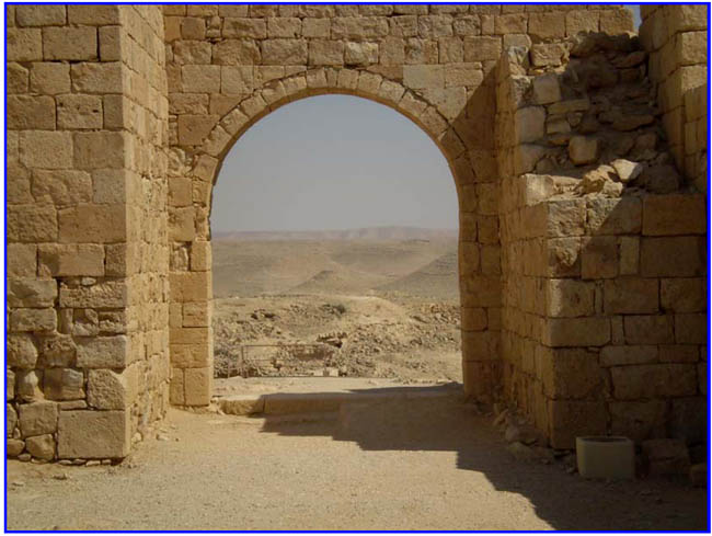
Figure 13 : View of valley through main entrance
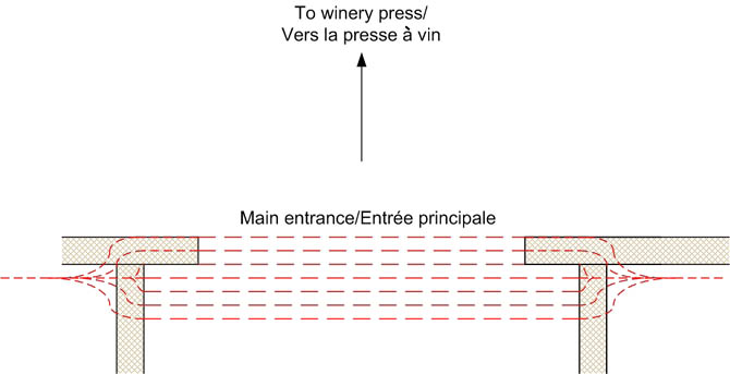
Figure 14 : Splitting of lines at entrance
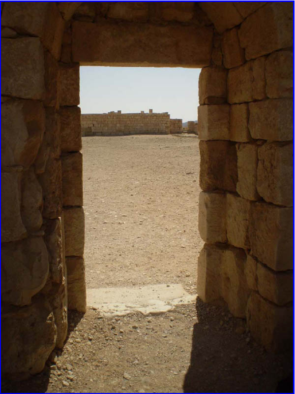
Figure 15 : Entrance to the plaza (Sacred Precinct)
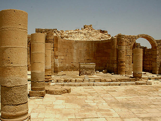
Figure 16 : Frontal view of St Theodore
Nabateans (1) – a Semitic people who inhabited Negev and ancient Edom in Transjordan from 3rd century BCE to 7th century CE. Were nomads at first, and then turned into traders and lead caravans along the Spice Route (ancient route for trade caravans bringing spices from Arabia to Mediterranean shore). They founded six cities in the Negev. Left no written records, but mentioned in Greek and Latin sources.<<Back