


Unlocking the mysteries of Rujm-El-Hiri
by Richard Benishai | Articles
What is this all about?
Near Moshav Yonathan, in the Golan Heights, there is a place which has been studied and photographed by many scholars and researchers. This place called “stone heap of the wildcat” in Arabic is referred to in Hebrew, as Gigal Rephaim (wheel of the giants). Since its discovery in 1967, this location has been investigated, measured, excavated, searched by radar, and probably more. The articles written of this remote spot are numerous; one only needs to query a search engine to find loads of data on this place.
Being a geobiologist, I approached this site with a different point of view: its energetic profile. This article deals with the physical side of the energy originating from the earth, as well as the spiritual aspects of this ancient location.
Some background
Having heard about Rujm-el-Hiri from a friend, as being one of the interesting places to visit in the Golan, I set out to look for this location, together with my son Tal. We looked and looked, but we could not find it. The area is not the friendliest around. It is strewn with rocks and bushes. So after a few hours, we gave up, having a long journey back to the Tel Aviv area. I went back again, alone this time. Still I found nothing, even with a good map.
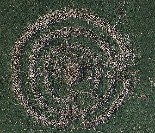
Figure 1: Rujm-el-Hiri, seen from above (credit: Itamar Greenberg)
For my third attempt (September 2004), I enrolled the help of some of the people from Moshav Yonatan. They guided me there.
Indeed, the place is impressive: the largest circle being over 150 m in diameter; four circles altogether, composed of more than 42 thousand stones; and in the center a big pile of stones (Figure 1).
The first thing I asked myself was why would people do such a thing? Apparently it was a lot of work, handwork that is, for a long time and by a lot of people.
What motivated them?
Latest trip
I went again with my son (2/10/07). This time, I knew how to get there:
1. You go to Moshav Yonatan and go through the back gate (this gate closes sometimes, so have someone’s phone from the Moshav, to have it opened).
2. Drive the back road for a long time until you come to the place shown in Figure 2 and Figure 3.
3. Drive past an abandoned army bunker and continue straight. The site will be seen on the left hand side.
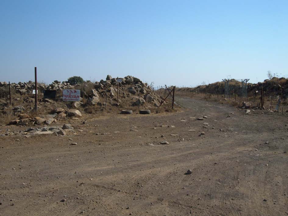
Figure 2: When you get to this point, stop and look to the right
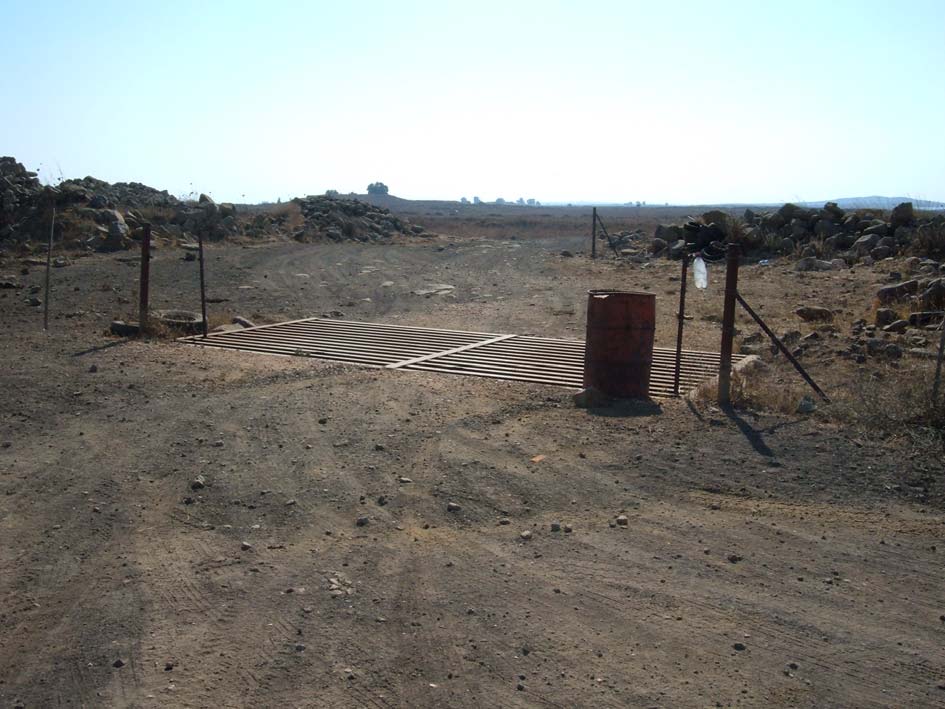
Figure 3: Drive straight through, over the grill
The physical site
Somewhere along the way, you will see the site. It is across a small river which can be crossed by two people, holding one to the other, for better stabilization. If you want to enter the outer circle without having to climb over the walls, then make a right and go around the back end, to the northeast entry, shown on Figure 4. There you will see a recently dug-out pit, which was not there back in 2004. Why to dig there? I don’t know. All there is below are rocks and more rocks (Figure 5).
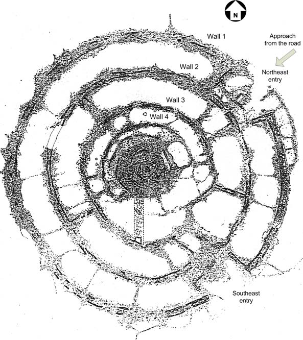
Figure 4: Rujm-el-Hiri Overview
Why this place?The first time I reached Rujm-el-Hiri and I had a chance to look over the place, and take some measurements, I was amazed by its sheer size and magnitude and also by the energy levels there. |
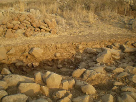 Figure 5: Excavating for stones? |
He said to me two weeks later:
“This place exists for 3200 years. It is positive to man and was used to heal. There were ceremonies and offerings done there: flowers, fruits and crystals. The stone circles stand for the earthen gods and fertility, with each circle representing a season of the year or a god responsible for that season.
People respected much this holy place and were sure to give thanks to the gods and entities. The knowledge to build this place came from the ancient Babel. Rujm-el-Hiri is energetic and the waters there contain many minerals good for the health. The waters are good for bathing and drinking.
Even though the ceremonies held there in those times were Pagans, it is known that Jewish people came to the place to get blessings and healing.
People visiting there (today) should connect with the place spiritually, giving thanks and respecting the entities and earthly gods located there, all this to create a positive energy circle, so as to maintain a future with blessings.
When well known, the site was managed by a priestess named NOGIA NOGIA. Her name meant: Touches god and gives blessings of ancient gods.”
I am not sure that everything channeled to my friend is correct, but while researching some documents on the net, I came the following paragraph from an article by Yonni Mizrachi, who is one of the most (if not the most) knowledgeable person on Rujm-el-Hiri. His article written several years ago certainly reinforces the information channeled.
“We see the function of Rujm el-Hiri as being primarily a ritual center and/or a temple in which religious ceremonies and ritual observations were attended by the urban populations who inhabited the newly emerged Golan “enclosure” sites (Mizrachi 1992a: 195-196, 228-242).”
Excerpt from The Geometry and Astronomy of Rujm el-Hiri, a Megalithic Site in the Southern Levant,
by Anthony Aveni, Colgate University and Yonathan Mizrachi, Tel-Aviv University.
The study
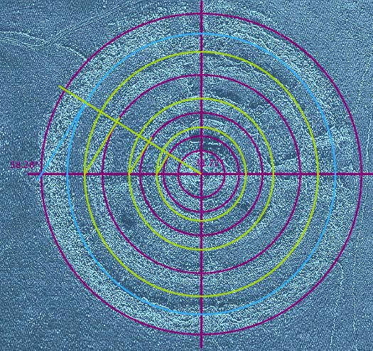
Figure 6: The regulating trace of the site
While many researchers have studied this structure, none have looked into the energetic side of the site. My knowledge in Geobiology has lead me to believe that throughout the ages and even up to 1400 A.D., man has always used underground singularities (faults, water veins, vortexes, etc…) in the planning and in the locating of sacred places.
Rightfully I assumed that there was a possibility of such use here. And indeed there was, as explained further on. In parallel, I approached my good friend Stephane Cardinaux, from Switzerland and sent him the top view of the site. He came back with the following reply.
Here is what seems to be the regulating tracing of Rujm-el-Hiri, as shown in Figure 6:
1. The large circle around the outside perimeter (in red), allows to draw all the other red circles by dividing each one successively by the golden number (1.618, also known as PHI).
2. The yellow circles are created by drawing tangents to the red circles at an angle of 58.28° which is the angle formed by the diagonal of a golden rectangle.
3. The blue circle is tangent to the line forming an angle of 58.28° with the diameter.
To conclude: the golden number allows the tracing of both sides of each of the walls.
While this configuration seems amazing for a construction done such a long time ago, it is not surprising. Man-made structures with extremely high accuracies were made as far back as 5100 years ago. I am referring to a monument in Morbihan, in France, a site recently discovered in 1963 (Figure 7).
This place is 17 m long with a 10 m entrance path. Within this underground tunnel, several stones were erected. What is amazing about the entire structure is that ALL dimensions are according to PHI, the golden number (1.618). Also, the angles formed by all locations within the site are all according to PHI. And to top it off, the various dimensions form a Fibonacci series.
One is to remember that in those days there were none of the measuring means we have at our disposal today.
And sometimes we find and measure some sites without making any connection with the Golden Number. As an example, the cromlech of Borrowston Rig, in Scotland, discovered by Alexander Thom, is about 4500 years old. While the author measured this place with accuracy, he did not make any correlation with PHI.
.
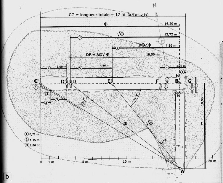
Figure 7: A 5000 year old monument (from Robert Chalavoux)
Energy parameters
The following paragraphs provide an overview of energy parameters used in the measurements taken at Rujm-el-Hiri.
Introduction
Our entire universe is full of energy fields and vibrations. We and the environment we live or work in are constantly affected by each other’s vibrations, since our thoughts are energy and vibrations. The quality of any place can be qualitatively measured by checking certain parameters, such as: basic vibrating level, magnetism, color wave form and ratio of cosmos to earthly energies. All measurement levels can be acquired using a pendulum and related graphs.
Basic Vibrations
The vibrations (energy) of any location can be measured in terms of Bovis units, named after Antoine Bovis. These units are used to indicate the vitality of a place or of an object, that of food, or the health of a person. The Bovis scale measures the size of wavelengths of light particles or Bio-photons which are invisible light particles.
Up to several years ago, the vitality of the planet was measured at 6500 Bovis units. Then, a few years ago, this number shot up to 10,000 units. Today, the Earth is vibrating at 12,000 units. This level is for a neutral location, which does not take or give energy. I have measured energy levels as low as zero Bovis units (and sometimes even negative levels) for places riddled with underground streams and/or faults.
Usually, standing on an underground stream will bring a reading of 4000 Bovis units. After completing a clearing, the energy of a house may reach 60,000 Bovis.
Color Wave Forms
Wave fields are generated by all vibrating elements. These fields influence our health by resonating with our cells which act as oscillating circuits. The field so created, resonate over the entire spectrum of colors, some visible, others not. The spectrum is further divided into electric and magnetic phases. Research has shown that a magnetic field is beneficial to man, whereas an electric field causes harm.
Some examples of wave form colors:
□White (magnetic phase) represents a spiritual location.
□ Ultra violet (UV) is a high positive level, within the magnetic or beneficial phase and sometimes found in homes.
□ Green positive (not a color) corresponds to a sacred or beneficial location.
□ Red (electric phase) corresponds to suffering or destruction of the place by fire.
□ Green negative (not a color) is found at locations where people were tortured or sacrificed. It is also the color wave form for a location where underground stream and pathogenic networks meet.
□ Black (electric phase) represents death.
Worlds Classification
When dealing with any location, one can categorize that place within one of seven worlds. The worlds are:
□ Physical
□ Etheric
□ Astral
□ Mental
□ Causal
□ Spiritual
□ Divine
High Level Places
For high-level locations it is well to relate in a manner where values are relative, instead of using Bovis units. The values are then indicative of the energy level for the particular location. The results are given in HLP (high level places).
Each category is divided into 7 steps, for a total of 49 steps, ranging from 1 to 49.
Energy Levels at Rujm-el-Hiri
In order to evaluate the energy levels at Rujm-el-Hiri, measurements were taken at each ring and in between rings. Several parameters were taken into account and the results are given in Figure 8. The parameters are identified in the following example
|
500 kB = energy level in Bovis units (Basic Vibrations) UV Mag. = color vibration and phase (Color Wave Form) Mental (25) = type of world and level (Worlds Classification) 200 HLP = Relative level of energy (High Level Places) Strong = relative indication of energy level. |
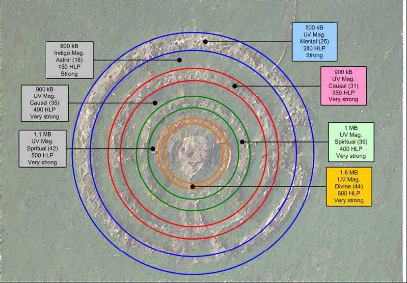 Figure 8: Rujm-el-Hiri with energy mapping
Similarity with more recent constructions
In my studies in Israel and in France of ancient churches and synagogues, I have always seen the same type of construction and disposition of the buildings in respect to the geology. Indeed, in all cases the main hall is always centered over a fault and sometimes an underground current (in this case, a wet fault). And even more, if the fault makes a deviation at some point, so does the building.
Thus, in Rujm-el-Hiri, I looked for an underground current and sure enough, there is one. The current flows from west to east, has a 2.10 m width and runs at a depth of 33 meters. The rate of flow is 5 m3 per hour. In addition to the current, there is also a 6.70 m fault at a depth of 51 meters.
When standing in the center of the underground stream, about 10 m from the outside wall, the energy level was 4 kB, as usually expected. As I approached the wall, the energy level increased rapidly. At a distance of 2 m the level was already 100 kB.
The form is the secret to this high level energy. The large amount of stones piled in circular and concentric configurations provide for a change in the phase of the energy and its high level. I have seen this happening in sacred buildings: the water energy is negative outside and up to the perimeter of the building. Immediately within the perimeter, the polarity changes to positive, due to the form of the building.
This is the case at Rujm-el-Hiri. On the other side of the site (east), the energy level is still very high, even far away from the outside wall. The furthest I could check was 20 m, due to a fence and mine warnings that stopped my passage. Even at that point, the level was 900 kB.
An energetic connection
When standing at the fence, on the east side, I noticed a hill, in the far distance, with a large antenna on top (see Figure 9).
| Once again applying the knowledge gathered from earlier experiences, I considered the possibility of Rujm-el-Hiri having an energetic connection with the hill. Searching, I found a 1.5 m wide link to the hill. The energy level while standing on the link was 1.1 MB (1.1 million). It would be interesting to look into that hill. Such energy links are found in France and for sure in other places, connecting small and large churches from one village to the next. |
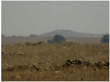 Figure 9: Hill in the distance |
Why are flowers growing only here?
There is a particular and single location in front of the central hill or tumulus where tall flowers grow (see Figure 10.
Seemingly an unusual place for plants to grow, I checked the energy level there and found 1.7 MB! Further investigation revealed that there was a 1.20 m diameter energy chimney in the center of this area.
About chimneys, please refer to our article : Chimneys and vortexes. Apparently the plants are growing in this dry spot due to the high energy level.
The rise and fall time of this chimney was 45 seconds each and its rest period was 15 seconds.
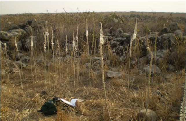
Figure 10: Plants growing in single location
The tumulus
The central mound (see Figure 11) is quite large and several meters high. It is best accessed from the east side. A schematic representation is given by Figure 12.
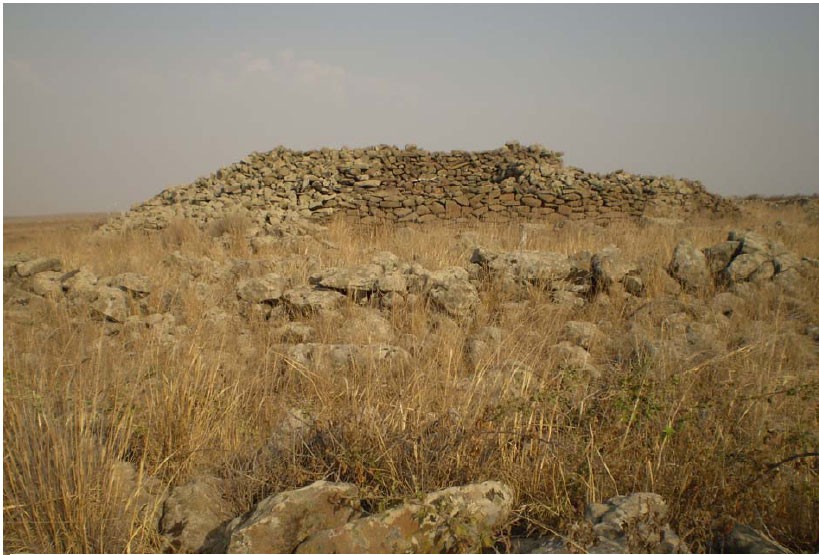
Figure 11: View of tumulus
Once on top, I saw a small hole and a larger one. Both accessed a tunnel inside the tumulus (see Figures 13 to 16.
While at the top of this hill, I checked the energy level. I measured 2 MB. While taking measurements, I felt tingling sensations in my fingers. Mentally I opened this place and made another reading. The level went to 4 MB.
While standing above the very center of the tunnel, I located a high-energy center: a chimney having a one minute rise and fall time each and a 20 second rest period.
I performed a harmonization process at this spot. Thereafter the energy level went up to a staggering level!! The energy parameters checked were the highest possible:
| 6 MB = energy level in Bovis units (Basic Vibrations) White Mag. = color vibration and phase (Color Wave Form) Divine (49) = type of world and level (Worlds Classification) 2000 HLP = Relative level of energy (High Level Places) Exceptional = relative indication of energy level. |
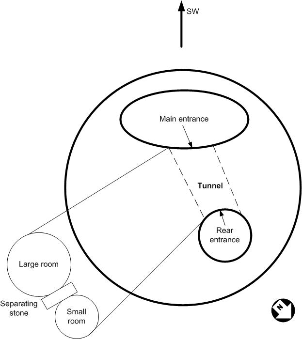
Figure 12: Schematic representation of the tumulus
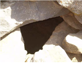 Figure 13: Main entrance to the tumulus |
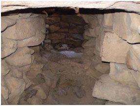 Figure 14: Inside the large room |
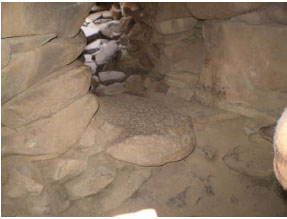 Figure 15: Large separating stone |
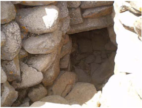 Figure 16: Rear entrance |
In conclusion
This place took an enormous amount of man power to build. I don’t believe that people in those days, concerned with basic survival, would spend so much effort in a construction used to view the stars or to know when the longest or shortest day will be. Easier and simpler formations could have been used. I do however agree with the idea suggested by some that this place was used as a location for rituals and ceremonies. I base my thoughts on the parallelism of the exploitation of the geographical/geological area to obtain a high energy level:
1. Underground fault and underground stream
2. Powerful chimney in the very center of the tumulus
3. Another chimney in line with the fault
4. Creation of an energy inverter by forming concentric circles
For more information, one simply enters Rujm-el-Hiri or Rogem Hiri in a search engine, to obtain hundreds of references.
Rujm-el-Hiri revisited
In February 2008, I went again to visit Rujm-el-Hiri, this time with a friend, who does spontaneous channeling while alert. Géèma (his channeling name) is also a geobiologist. He has the special ability to see the invisible to the naked eye. We arrived there, after having spent some time in Kursi (see the revised article). We were not able to approach the site due to a small river blocking our way (we came to learn later on that this obstacle in our path was not accidental).
Géèma then sat down in the car and started to write. His writing was spontaneous, while in mental contact with his usual source (his “family”). The transcript of this communication follows.
“In front of you, you have what we may refer to, as the “perfect point” the center and the extensions of the center, in form of circles. [Much similar to throwing a stone in a pond and watching the waves spread].
It is true that there are several interpretations on the nature of this site. It is a highly energetic site, even though its level of vibrations is inferior to that you have visited the same day [Kursi].
This location is an energetic center for curing illnesses.
At the very start, living areas were established at the northern section of the circles, prior to their creation. Then, the shamans of this pagan civilization noted that there were numerous illnesses among their people and even among the animals.
The shamans set up [spiritual] connections to find out the reason for these illnesses; as a result, these circular walls were erected, around the perfect point, according to instructions received by the shamans. The central point can be considered as a chakra of the Earth for this area.
Exceptional results were obtained and offerings were continuously presented to these circles, considered as spirits. Each season, offerings were made to different spirits. Many years later, invading forces destroyed or banned the inhabitants from this site.
The new settlers never knew the reason and use of these circular constructions and their perfect geometry. They used the circles for everything and for nothing and especially to protect their wives, children and beasts from the threat of invaders.
If you want to use this site, it cannot be for monetary gain; it must be open only for esoteric teachings, for the hidden or sacred sciences and also for people suffering from respiratory illnesses.
This site must not be repaired or restored; leave it as is, because some things that cannot be disclosed must not be modified by accident.
Come back to visit this site in some time, because certain energies are going to change.”